Arturo Abuyen thought he was ready for the storm. The night before Typhoon Haiyan was expected to hit Filipino shores, the police station that he commands in Tacloban had extra officers on duty, a vehicle standing at the ready, and a stockpile of fresh water. “What we are preparing is what we heard from different radio stations, TV stations,” he recalls later. “But the typhoon was very strong.” Far stronger than he expected.
Haiyan’s winds and storm surge ripped the roof off the station and collapsed its second story. Abuyen and other officers had to swim for their lives, making it to the second floor of a supermarket across the street. Their vehicle was also destroyed in the rapidly rising, fast-flowing waters.
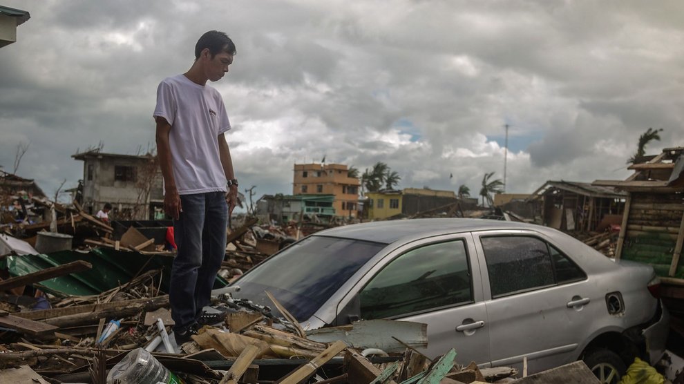
A similar story played out across the city. Police and social workers had staged cars, food, water, and other emergency supplies close to the coast so they’d be ready to help storm victims—only to see them destroyed or swept away. Many people made the fatal decision to ride out the storm in their homes rather than evacuate.
The Philippines is the most storm-exposed country in the world, hit by typhoons around eight times each year. “We are used to typhoons here,” explains Norman Fevidal, a police investigator. “We would have category threes before, we would just laugh about it.” People knew that Haiyan was coming, they knew it would be a powerful storm, but they didn’t expect it to be a monster.
Forecasters were initially caught off guard, too. As the storm strengthened over Micronesia on November 5, 2013, the Joint Typhoon Warning Center predicted that Haiyan would become a powerful tropical cyclone with sustained winds of nearly 140 miles per hour—equivalent to a category 4 hurricane—by the time it hit the Philippines a few days later. When Haiyan slammed into Tacloban in the early hours of November 8 th , its sustained winds had reached 195 mph, with gusts hitting 235 mph. It was the fourth strongest typhoon in history and the strongest ever recorded at the time of landfall.

Understanding the Storm
In recent decades, forecasters have gotten considerably better at predicting the paths of hurricanes and typhoons, also called tropical cyclones. Gone are the days of frequent and majors errors in predicting a storm’s track, as well as the unnecessary evacuations of long stretches of coastline. But sudden changes in intensity—and with them, unexpected wind speeds and storm surges—continue to be hard to foresee. Forecasting models sometimes miss badly, and it’s the extreme cases that are both the deadliest and the most difficult to predict.
More accurate forecasts of such storms, or even a few days’ improved notice, could save lives and property. “If you knew with some certainty that this was going to be a 130-knot storm versus a 90-knot storm, that affects how you prepare,” explains Patrick Harr, a meteorologist with the Naval Postgraduate School who studies typhoons in the western Pacific. “That’s not beyond the realm of possibility to be that far off.”
Understanding changes in the intensity of tropical cyclones could do more than help us just predict wind speeds. After Hurricane Katrina intensified rapidly in the Gulf of Mexico, it suddenly changed structure, becoming weaker but broader and sending an unexpected and devastating storm surge into New Orleans. Hurricane Sandy’s sudden left turn, which sent it barreling toward New York, followed an abrupt change in intensity.
“These kinds of changes, we have just not a clue right now as far as what causes them,” says Peter Black, who studies tropical cyclones as a contractor for the Office of Naval Research’s Marine Meteorology and Effects Program. But he and other scientists do have a hypothesis, which is just beginning to be tested. Black analyzed storms which had been inaccurately forecasted and noticed that something seemed to be happening at the storms’ upper levels, a high-altitude region that’s “basically unexplored,” says Ron Ferek, a program officer for the ONR. (The ONR has an obvious interest in solving that problem. As Harr explains, “tropical cyclones are about the largest peacetime impact to the Navy. It costs a lot of money to stay out of their way.”)
But testing that hypothesis hasn’t been easy. The famous “Hurricane Hunters,” manned planes that fly into tropical cyclones in the Atlantic to capture data about them, can’t fly at storms’ highest levels. Satellite data is similarly inadequate since it can’t capture the details of a cyclone’s vertical structure. That lack of data is a problem: When a storm’s dynamics are significantly influenced by high-altitude processes, Ferek says, “our forecast systems blow the forecasts because we’re not capturing that physics.”
Send in the Drones
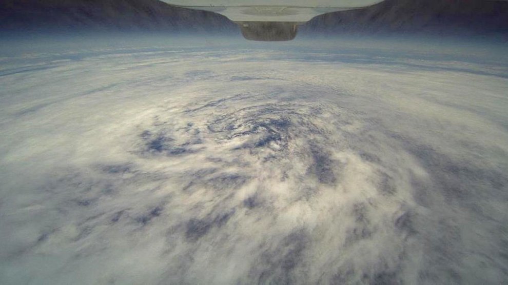
Scientists are hopeful that the advent of unmanned aerial vehicles—drones capable of flying high above tropical cyclones—will help change that. This August and September, a pair of NASA Global Hawks, capable of flying higher than 55,000 feet, will complete their third and final season of a test project surveying Atlantic hurricanes. The Hawks, part of a mission known as Hurricane and Severe Storm Sentinel, or HS3, are outfitted with specialized sensing equipment to take measurements of wind, precipitation, temperature, humidity, and air pressure above and inside the storm. One will release dropsondes, parachuted monitoring devices, above storms; the sondes take multiple readings as they fall through the storm to the ocean’s surface, giving meteorologists detailed information about a storm’s internal structure.
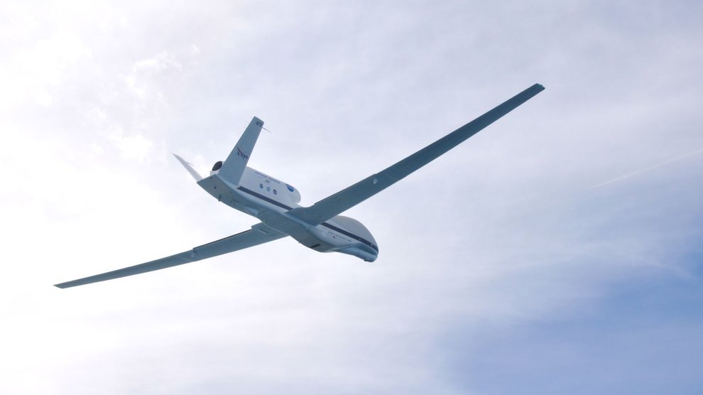
“Global Hawks represent the first opportunity anybody has had to make direct observations of the upper level part of tropical cyclones,” Black says. That region where air is sucked up and out of the center, he says, “is just as important as the low levels where the air spirals in towards the center.”
Air that leaves a tropical cyclone doesn’t always do so uniformly. Outflows tend to happen at high altitudes in concentrated, high-speed jets that can extend out from the storm for thousands of kilometers and interact with the jet stream in unknown ways. “We don’t know much about what determines the orientation” of these outflows, Black explains. But scientists do think the outflows are linked to unexplained rapid intensifications, when wind speeds increase by more than 40 mph in less than day. Black says solving that riddle “is really the key tropical cyclone forecast problem right now.”
Researchers are using the data that UAVs capture to study how energy gets transmitted through and then out of cyclones, as well as how outflows interact with the surrounding atmosphere, potentially steering storms or changing their intensity. They’re testing the hypothesis that the data from UAVs can improve forecast accuracy, particularly when it comes to storm intensity. An upcoming collaboration between the National Oceanic and Atmospheric Administration (NOAA) and NASA will attempt to quantify how much each observation contributes to the overall accuracy of forecasting models. One early test, in which scientists reran prediction models for 2012’s Hurricane Nadine with data from the Global Hawks, found that the prediction was some 30% better. “We’re finding all sorts of structure and detail that we were really unable to observe before,” Ferek says.
Testing has so far taken place only in the Atlantic, but researchers are eyeing a project in the Pacific as soon as 2016. UAVs could be particularly useful there. Though the U.S. used to send monitoring flights into typhoons as well as hurricanes, most Pacific flights were discontinued in the late 1980s due to a combination of budget cuts and the improved availability of satellite data. Today, most cyclones in the western Pacific are no longer flown at all. Taiwan has a jet that flies around, but not into, storms that threaten the island, and the U.S. flies only those typhoons that are expected to hit Hawaii. Most forecasts for typhoons are based only on information from satellites. Unlike models used in the Atlantic, which use storm-specific data to create dynamic forecasts, they’re statistical models that rely on averages. As a result, typhoon forecasts tend to be somewhat less accurate than hurricane forecasts.
That problem is likely to be compounded in the next few years. Many of the U.S.’s weather monitoring satellites are reaching the end of their lifecycles, and due to planning and budget problems, replacements will likely not be launched in time to fully replace them. Meteorologists say we are living on borrowed time at the end of a golden age in satellite monitoring: Aging satellites could fail at any time, leaving us with dangerous gaps in information .
That’s particularly troubling in the Pacific, where there are few alternative data sources to fall back on. “That’s a big problem for the typhoon community, especially the Joint Typhoon Warning Center,” Black says. “Satellite data’s the only thing they rely on to do these intensity estimations that provide guidance for the forecast.” While UAV data isn’t a substitute for satellites, he’s hopeful it can at least be “what we call a gap-filler” to help see forecasters through the satellite crisis. Farr agrees: “They’re not going to fill the gap 24 hours a day like a satellite does, but they can be targeted over high-impact weather events at key times.”
Improving the Models
Still, not everyone is convinced that UAVs are worth the trouble—Global Hawks are expensive, at around $130 million each, and their contributions to forecasts have yet to be fully tested or quantified. At this point, Ferek says, “we don’t really think about it as a potential future observing capability for operations. What it really does is allow us to do some science that we haven’t been able to do in the past.” In other words, Hawks aren’t likely be performing regular storm reconnaissance in the style of Hurricane Hunters anytime soon.

Ferek’s hope is that the research with Global Hawks will help meteorologists understand the upper reaches of tropical cyclones better, allowing them to refine forecasting methods so they can perform better even when data from UAVs isn’t available. The mystery of cyclone outflows, Ferek says, is “one of these fundamental knowledge barriers that we think we need to overcome to get to the next level of skill in prediction systems.” It could also improve weather forecasts around the world, since it’s assumed that powerful outflows interact with the jet stream, influencing weather in places far away from cyclones.
Peter Black estimates, roughly, that only 10% of tropical cyclones are extreme events, but that those 10% are responsible for 90% of damage. The difficulty is being able to predict which storms will become extreme and which won’t.
Haiyan, of course, was one of the 10%. When I visited Tacloban three months after the storm, Abuyen and his officers were still working out of a shelter built of tarps and plywood in front of the ruins of their former office, transporting anyone they arrested on the backs of personal motorcycles. A short distance away, families cooked breakfast in the shade of a pair of massive container ships that the storm surge had left behind. No one laughs about typhoons anymore: Over and over, survivors told me how they had huddled in fear during even the mild storms that had hit since Haiyan.
But more serious storms are on the horizon. Scientists have predicted that the intensity and frequency of tropical cyclones will increase with climate change. “The only thing we’re ever going to be able to do is improve awareness, improve the forecast, and hopefully mitigate the impacts of storms like that,” Black says. “You have to tell people, this is not going to be just your everyday typhoon, it’s going to be life-threatening.”
